Philadelphia region digging out from winter storm | Live Updates

WPVI logo
Last updated: Tuesday, January 27, 2026 4:28AM GMT
6abc Philadelphia 24/7 Live Stream

PHILADELPHIA (WPVI) -- The massive cleanup effort will continue on Tuesday after a winter storm slammed the Philadelphia region.

Officials have stressed that road conditions may still be dangerous, especially with temperatures plummeting this week.

The next chance of widespread precipitation doesn't come until the weekend, and we will be watching to see whether a nor'easter forms and tracks along the coast or mainly stays out to sea.

Visit 6abc.com/weather to watch the latest AccuWeather forecast.

You can share your weather photos with us by visiting this link.

Here are the latest headlines as the cleanup begins.

WPVI logo
Jan 23, 2026, 4:02 PM GMT

Trash and recycling collection suspended Monday in Philadelphia

Trash and recycling services will be suspended for Monday, Jan. 26, and collection for the rest of the week will be pushed back one day.

Clean and Green Director Carlton Williams said this will help make sure all city resources are dedicated to snow removal following Sunday's storm.

Residents are asked to hold their trash and recycling for the next day.

There will also be no two-day-per-week trash collection for neighborhoods that receive that service, Williams said.

All driveway collections are suspended, Williams continued. Residents who have driveway collections are asked to bring their trash out front or use the drop-off center.

Further adjustments could be made, and residents are asked to pay attention for updates.

WPVI logo
Jan 23, 2026, 3:56 PM GMT

Snow Emergency to start in Philadelphia at 9 p.m. on Saturday

A snow emergency will be in effect for Philadelphia starting at 9 p.m. on Saturday, Mayor Cherelle Parker announced at a Friday morning news conference.

It will remain in effect until roadway conditions improve, Parker said.

She asked city residents to move cars off snow emergency routes by that time.

The winter storm this weekend could bring 8" to 10" of snow to the city on Sunday, according to AccuWeather.

For the latest forecast and StormTracker 6 radar, visit 6abc.com/Weather.

AP logo
Jan 23, 2026, 2:37 PM GMT

How big winter storms create snow, sleet and freezing rain

When big winter storms move in, they can bring nasty weather that ranges from snow to sleet and freezing rain - or maybe extreme and dangerous cold.

Here's a look at some weather conditions and how they vary from place to place.

How snow might become ice or sleet on the ground

To stick, snow needs consistent cold air all the way from where flakes form in the clouds to the ground. If it's below freezing the whole way, the snowflakes never melt, so nothing turns to ice.

"The further north, the deeper that Arctic layer is, the more likely to support snow," said MIT research scientist Judah Cohen.

Farther south, the atmosphere may include a sandwich of warm air between cold layers. That's how sleet and freezing rain happen.

"The snowflakes form, they fall and then they meet a warm layer, a layer above freezing, and they will melt. But then there's another layer near the surface that's below freezing again, so they will refreeze before they hit the ground," Cohen said.

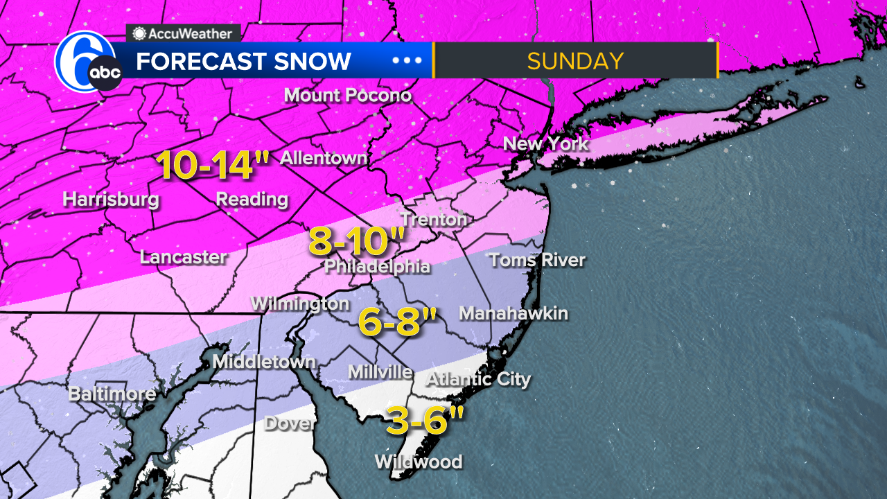
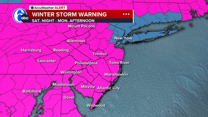
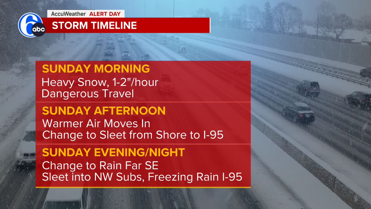
Live Updates: Major winter storm eyes up Philadelphia region; first look at snow totals

Sleet requires the lowest layer to be cold enough that raindrops refreeze when they hit the ground, creating bouncy ice pellets. If that lower cold layer is shallow, the rain doesn't have enough time to freeze in the air. So it hits the ground as raindrops that freeze when they make contact.

Then there's graupel, which is a rarer mix between snow and sleet. Not quite fluffy, and not quite hard.

"It's snow that has tried to melt on its way down, but not quite melted," said David Robinson, New Jersey state climatologist at Rutgers University. "It's out of that six-point crystalline shape and has begun to look more like a cotton ball. So it hasn't gotten to the point of full melt that it could then refreeze as sleet."

There's also hail, which Robinson said some people mistakenly use to describe sleet. But real hail probably isn't happening in a winter storm. That usually happens in the summer because it requires warmer air that's closer to the surface. That creates an updraft that allows rain to move up, freeze, fall, and move up again, forming layers of ice similar to the layers of an onion.

Different precipitation, different hazards

Snow can be dangerous - sufficient to send cars skidding into ditches and be life-threatening in whiteout conditions. But at least it can be plowed.

The ice in sleet makes it much more difficult to move.

RELATED: Get the latest on the approaching winter storm at 6abc.com/Weather

But the most devastating moisture is freezing rain, Cohen said, because it turns roads into skating rinks and can be so heavy it has the power to bring down power lines.

And then there's extreme cold.

When the National Weather Service deems expected temperatures and wind chills are low enough to be dangerous, they issue alerts.

A cold weather advisory means dangerous weather is likely. An extreme cold watch means life-threatening weather is possible. An extreme cold warning means life-threatening weather is likely.

___

The Associated Press' climate and environmental coverage receives financial support from multiple private foundations. AP is solely responsible for all content. Find AP's standards for working with philanthropies, a list of supporters and funded coverage areas at AP.org.

WPVI logo
Jan 24, 2026, 4:55 AM GMT

Here's how much snow could fall this weekend

Here's a look at your expected snow totals for the Philadelphia region ahead of this weekend's storm.

The forecast shows quite the gradation from I-95 to the coast. This is due to warm air moving in during the later part of the storm, leading to mixing across a large portion of the area. That mixing will lower snowfall totals for several locations.

The latest trend shows a stronger push of warm air aloft. That means more mixing farther north. So, that snowy winter wonderland Sunday morning turns into a sleet/icefest for most of our area by lunchtime.

Winter Storm Warning have now been posted for our entire area from Saturday evening into Monday.

TIMELINE

Sunday morning

  • Heavy Snow with rates of 1-2"/hour

Dangerous travel

Sunday afternoon

  • Warmer air moves in, allowing mixing to move northwest from the coast to I-95. This is when sleet will take over. Sleet arrives in Philly between 3 to 6 p.m.

Sunday evening

  • Far southeastern areas turn to rain as milder air moves in. Sleet may mix in as far north as the Lehigh Valley

  • I-95 could see a period of freezing rain at the end

  • Nothing melts for days as highs remain below freezing into later next week.