Jersey shore feeling impacts from Hurricane Erin as it races up the Atlantic Ocean
The National Weather Service expects the most widespread flooding to occur during the next high tide Thursday night

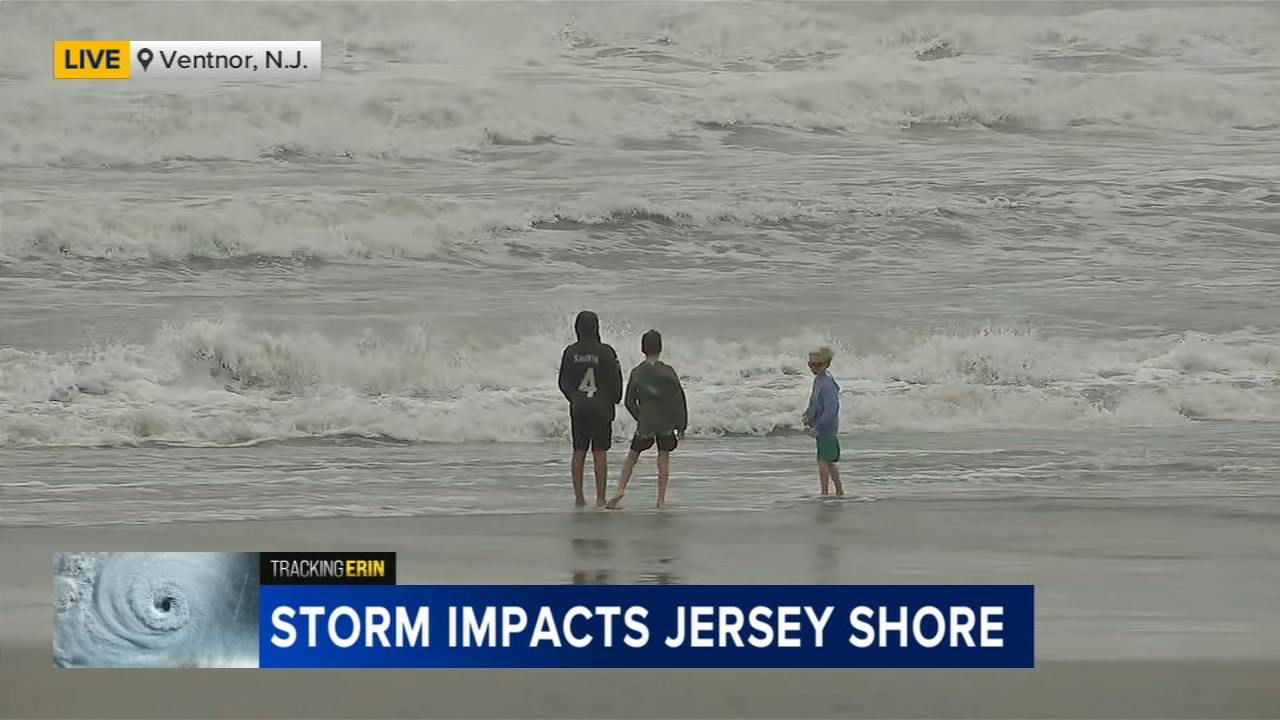
ATLANTIC CITY, N.J. (WPVI) -- Jersey shore communities are feeling the impacts of Hurricane Erin Thursday, as the storm makes its way up the Atlantic Ocean.
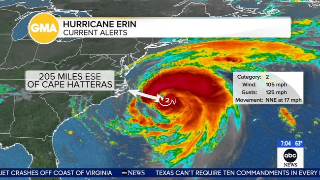
Despite the storm not making landfall, it is generating hazardous conditions up the East Coast.
"[Thursday] is going to be a messy day and a dangerous day," said Atlantic City Mayor Marty Small.
The ocean is closed for swimming until at least Friday, according to the Atlantic City Beach Patrol, which reported performing 45 rescues on Sunday.
Officials say surf conditions have worsened as the hurricane moves north.
"Right now, rip current is about as bad as it can get, and we expect that to continue through the next couple of days," Chief Steve Downey of the Atlantic City Beach Patrol said on Wednesday..
Officials issued a safety alert Monday restricting swimming and advising beachgoers not to enter the water past their ankles. Atlantic City is one of more than a dozen beach towns implementing restrictions.
So, the boardwalk is providing fun for kids who can't go to the beaches.
Action News Reporter Trish Hartman was at the Ventnor fishing pier, where she had a good view of the waves.
She said people had been coming up all day to check out Erin's wrath.
The beach patrol lifeguards are on duty, but they're just making sure no one is in the water. The chief said, even surfers, for the most part, have been staying out of the ocean just because the white water is constant.
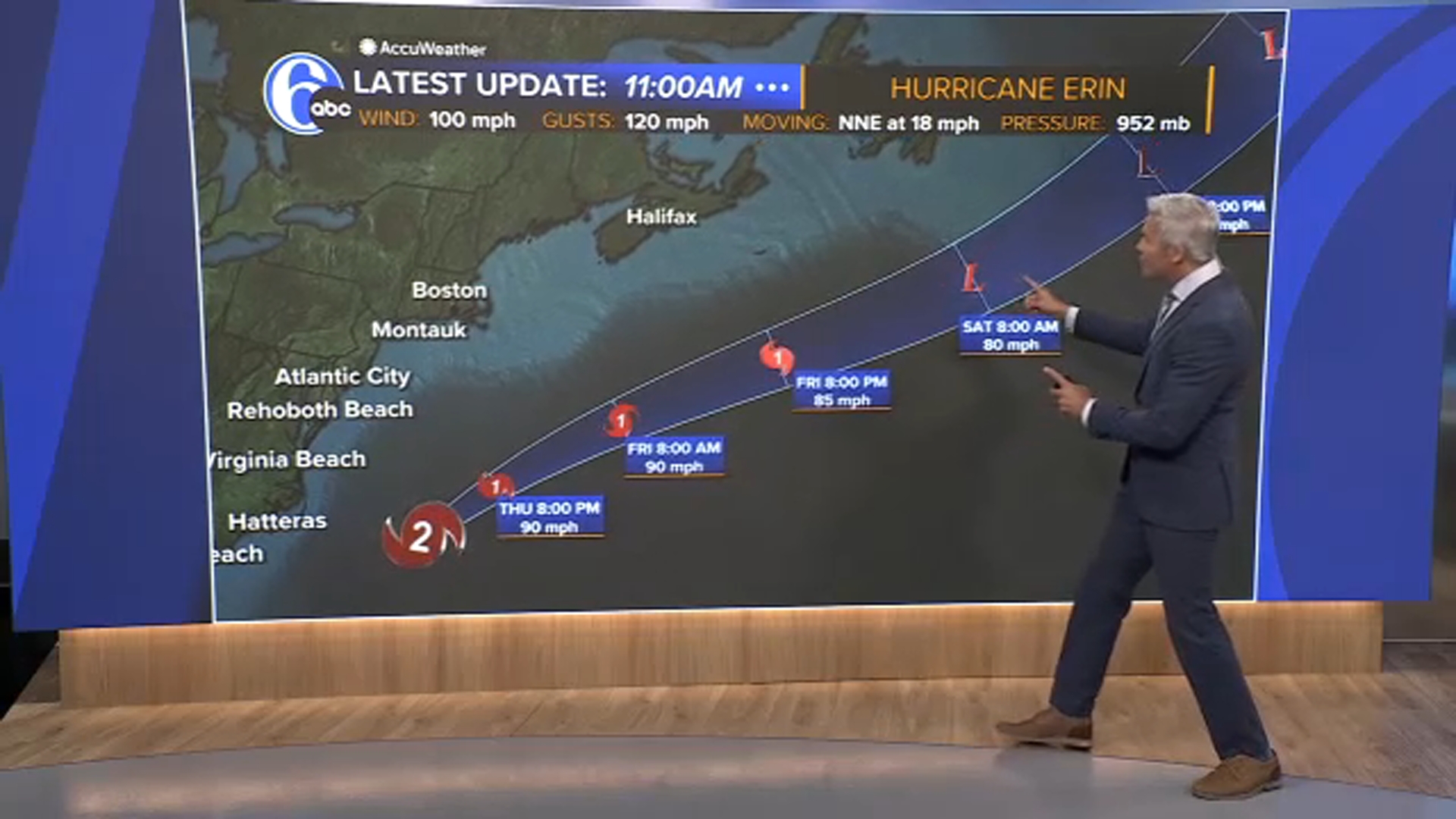
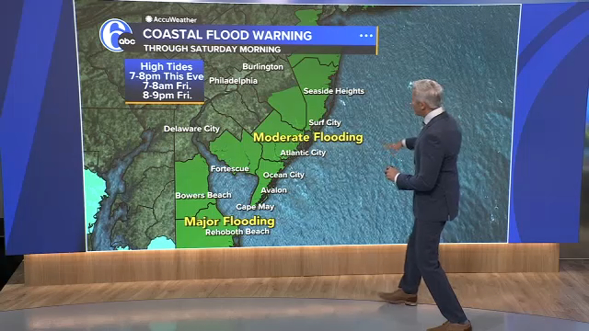
Another major concern: moderate coastal flooding, which peaks on Thursday evening.
The local OEM has high-water vehicles on standby. They're looking ahead to Thursday night's high tide around 7 p.m., where street flooding is expected.
"The city is increasing its capabilities to operate in flood environments, such as our high-water vehicles and the waders, the flat-bottom boats," said Scott Evans, Atlantic City's emergency management coordinator.
Cars parked in those trouble areas could definitely take on water.
RELATED: Hurricane Erin stirs up strong winds and floods part of a NC highway as it slowly moves out to sea
Officials really don't want people driving through water, not only because you could get stuck, but larger vehicles can create a wake as they drive through, which can cause property damage or properties to take on water.
Areas prone to flooding that will likely close later Thursday include Dorset Ave., near the bridge, as well as Wellington Ave., near Ventnor Plaza.
"Based upon what the projections are, we are already anticipating and warning people Route 40 will be closed," said Evans.
City officials released a map showing areas expected to experience moderate flooding. Pumps will be operating to drain water off the island, but Evans warned of additional impacts.
"We are going to see some major beach erosion and we're going to see water in the streets," he said.
Officials said the Wave parking garage will be open and free to the public.
"Maintain situational awareness," Evans said. "Everyone should have a weather source, everybody should have a place where they get their information. One thing we always stress is look out for your neighbors."
Despite the warnings, some families vacationing in Atlantic City tried to make the most of their time before conditions worsened.
For the latest conditions on area highways, check 6abc.com/Traffic.
"You plan it in advance, but you can't control the weather," said Michelle Mann from Lockwood, New York.
While no evacuation orders are currently in place, officials had advised that if anyone was planning to leave, they should before high tide.
On Tuesday, Governor Murphy told people not to go into the water but left the decision up to individual townships.
Cape May County issued Coastal Flood Warnings alerting people to strong onshore winds, flooding concerns and tidal surges, including communities along the Delaware Bay.