Tropical Storm Sally expected to be Category 1 hurricane during Gulf Coast landfall Tuesday morning


This year's hurricane season is on pace to be the most active of all time, so it's no wonder that the tropics remain very busy.
The National Hurricane Center now sees several tropical waves in the Atlantic storm basin.
Tropical Storm Sally is just off the west coast of Florida and is expected to strengthen into a hurricane by late Monday.
Sally is moving northwest at 8 mph across the Gulf of Mexico with maximum sustained winds of 60 mph.
Sally is expected to bring extremely dangerous and life-threatening storm surge. Storm surge warnings have been issued from Port Fourchon in Louisiana to the Mississippi/Alabama border.
Tropical Storm Sally is expected to be a Category 1 hurricane with a Tuesday morning landfall near New Orleans. The northern Gulf Coast will begin feeling Sally's effect as early as Monday.
Sally is the earliest "S" storm in recorded history.
Preparing your hurricane kit during COVID-19

Out in the Atlantic, Hurricane Paulette is moving northwest at 13 mph with maximum sustained winds of 85 mph.
The eye and eye wall of Paulette is nearing Burmuda on Monday morning.
After hitting Bermuda, the storm is expected to turn north and stay away from the United States. Swells from Paulette are expected to impact parts of the Leeward Islands, the Greater Antilles, the Bahamas, Bermuda and the southeastern United States.
Rene is currently a tropical depression out in the Atlantic Ocean moving northwest at 6 mph with maximum sustained winds of 30 mph.
What happens when we run out of letters of the alphabet for hurricane names?
The west coast of Africa is also busy; there are two tropical waves near the continent.
Tropical Depression 20 has formed off the west coast of Africa. The depression is moving west-northwest at 10 mph with maximum sustained winds of 35 mph.
Another tropical wave off Africa's coast has a 70 percent chance of formation in the next 48 hours.
There is another wave over the Gulf of Mexico that has a 10 percent chance of formation in the next 48 hours.
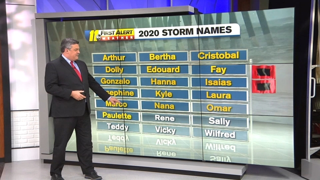
The next storm to become a tropical storm will be named Teddy, meaning there are only three more letters in the alphabet for storm names this year (Teddy, Vicky, Wilfred). Here's what happens if we run out of names.
The last time that happened was 2005--which is the current record holder for the most active hurricane season ever.