Storm moves out of Philadelphia region; much colder Tuesday

6abc Digital Staff Image
Last updated: Tuesday, March 17, 2026 5:49AM GMT
Live StormTracker 6 and Sky 6

PHILADELPHIA (WPVI) -- The threat of severe weather has moved out of the Philadelphia region.

There were Tornado Warnings issued in Kent County, Delaware, and parts of New Jersey, late Monday, but all warnings have since expired.

Temperatures quickly tumble overnight as cold air takes over. A wind advisory is posted for the entire region until 2 a.m. Tuesday.

Click here for the latest AccuWeather forecast.

Cecily Tynan Image
Mar 16, 2026, 9:02 PM GMT

Tornado threat diminishing

The western suburbs have been removed from the tornado watch.

Thick cloud cover has limited surface instability, keeping storms from turning severe.

We still have the strong straight-line winds with the cold front to watch, late this evening.

Trish Hartman Image
Mar 16, 2026, 8:27 PM GMT

Crews cleaning storm drains ahead of possible downpours

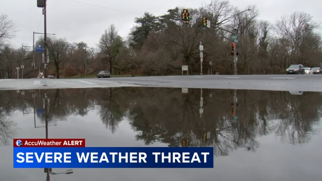
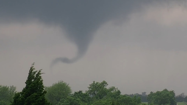
With the region under a tornado watch, folks were trying to plan their day to avoid traveling in severe weather.

"My car doesn't do really well in the rain, so we're just trying to get out as early as we can," said Dalexa Rodriguez of Reading, Pa.

Rodriguez and Kiancy Reyes were heading back to Penn State's main campus on Monday.

Crews cleaning storm drains ahead of possible downpours

"You just gotta keep your head on a swivel, pay attention. We'll be fine," said Kiancy Reyes of Bristol Twp., Pa.

They hit the road early, hoping to avoid some nasty weather.

Officials say crews in New Jersey and Pennsylvania spent the day cleaning storm drains and inlets in preparation for downpours.

"Today, they are picking up litter, which will hopefully prevent clogging storm drains or just having other obstructions along the road," said Helen Reinbrecht, PennDOT's District 6 Community Relations Coordinator.

Another concern with high winds expected: downed trees, wires, and power outages.

"PECO has developed an enhanced staffing plan for this event to ensure we have additional field crews on hand and on standby to respond to any outages to safely restore service for our customers," said PECO spokesperson Izamarie Camacho.

PECO says they're monitoring conditions and will call in help from outside the area if needed. They're urging people to be safe in case of an outage - and to be prepared.

"PECO customers should always assume that equipment is energized. We tell customers to report downed power lines by contacting us at 1-800-841-4141," added Camacho.

Mar 16, 2026, 7:56 PM GMT

Strongest wind gusts likely still to come

Remain weather aware the rest of this afternoon and well into Monday night.

The severe threat for our area will not be over until almost midnight.

Temperatures crash behind this front and the next two days will be around 10 degrees below average.

We're watching the low-level jet, which is a band of very fast winds about a mile above the ground. It peaks this evening & helps produce intense wind gusts at the surface. Watch for tree limbs, power-lines, & even outages.

Mar 16, 2026, 7:08 PM GMT

Tornado watch vs warning: What to do when you see alert messages

Tornado watches and tornado warnings have different purposes, and you should react to each differently, AccuWeather explains.

A tornado watch is typically issued hours in advance by NOAA's Storm Prediction Center (SPC). It means that conditions are ideal for a tornado to form. A watch will not necessarily result in severe weather, AccuWeather explains.

"A watch is issued when conditions are favorable, for example, either for a severe thunderstorm or tornadoes," AccuWeather.com Senior Meteorologist Dan Kottlowski said. "It doesn't mean severe weather is imminent."

Tornado watches and tornado warnings have different purposes, and you should react to each differently, AccuWeather explains.

If there is a watch in your area, you should keep an eye on weather alerts and be prepared to act. Make sure you know ahead of time what to do if a tornado hits.

While a watch covers a broad region, a warning is issued by a local National Weather Service meteorologist for a smaller area.

A warning means that either a tornado has been spotted or a radar has picked one up.

If you are in an area with a tornado warning, it's time to act immediately. Get to a safe space such as a storm shelter. If you don't have one, the best option is usually in the basement or the middle of a building, away from windows, preferably in an area with reinforced walls.

On rare occasions during significant events such as a tornado outbreak near a heavily populated area, a tornado emergency might be issued. The difference between a warning and an emergency has to do with how widespread the damage could be.

Just as with a tornado warning, those in the path of a tornado emergency should seek shelter and wait for authorities to say when it's safe to come back out.