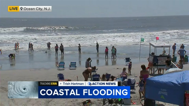
Coastal flooding remains concern at Jersey Shore as Hurricane Erin moves away from East Coast
New Jersey Governor Phil Murphy has declared a State of Emergency on Thursday for Hurricane Erin.

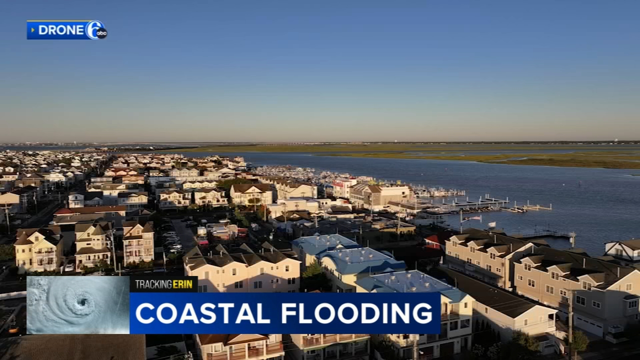
OCEAN CITY, N.J. (WPVI) -- Hurricane Erin lived up to expectations, causing coastal flooding and even leading to rescues along the Jersey Shore.
Coastal flooding will remain a major concern along the Jersey Shore throughout the weekend as the storm moves further out into the Atlantic Ocean, bringing dangerous surf and rip currents.
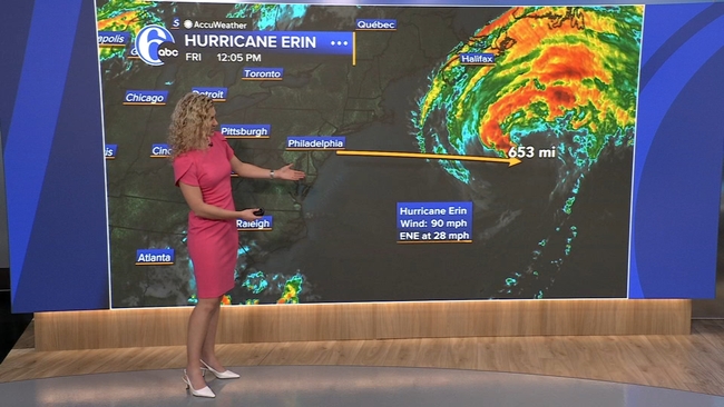
The National Hurricane Center in Miami reported Friday afternoon that Erin had weakened to a powerful extratropical low.
On Thursday, New Jersey Gov. Phil Murphy declared a State of Emergency in anticipation of flooding and hazardous surf conditions.
Murphy spoke at a solar event on Friday, where he addressed the impact of the storm.
"While it existed, while it happened, was less than we were fearing. Not surprisingly, coastal flooding was the big concern," he said, adding that, "Cape May County probably got hit the hardest."

He said the coast saw about 15-foot waves at its peak, pointing out that the ocean is still too dangerous to venture into for the next few days.
"The weather is going to be gorgeous this weekend, but please be careful as it relates to going into the ocean," Murphy said.
He also said there were a few power outages, with roughly 150 throughout the state.
Despite the remaining concerns, people are still flocking to the beach on Friday.
The sun may be out but beach restrictions are in place. The beach in Wildwood was actually closed for a while on Friday morning so crews could clean up debris.
Lifeguards have been keeping bathers very shallow next to Music Pier as folks try to enjoy what may be left of their vacation.
The DEP is assessing for beach erosion at various shore points throughout the weekend.
In Ocean City, officials say they'll have to wait for the high tides to die down so they can really assess the damage.
In Margate, city officials are asking people to check their homes for flood damage, especially homes that are in low-lying areas where the owners may not be there full-time.
Several businesses were cleaning up on Friday after taking on water during high tide.
On Thursday night, emergency vehicles were stationed on flood-prone streets as high tide approached. Videos shared with Action News showed flooding in towns including Ocean City and Margate.
Margate firefighters rescued more than 50 people from cars, restaurants and bars after tidal flooding from the storm.
Officials said at least 30 people were rescued from that one location during dinner Thursday night. They also rescued 16 people and three dogs from flooded vehicles.
On top of that, they had to deal with a gas leak, an underground transformer fire and an electrical fire.
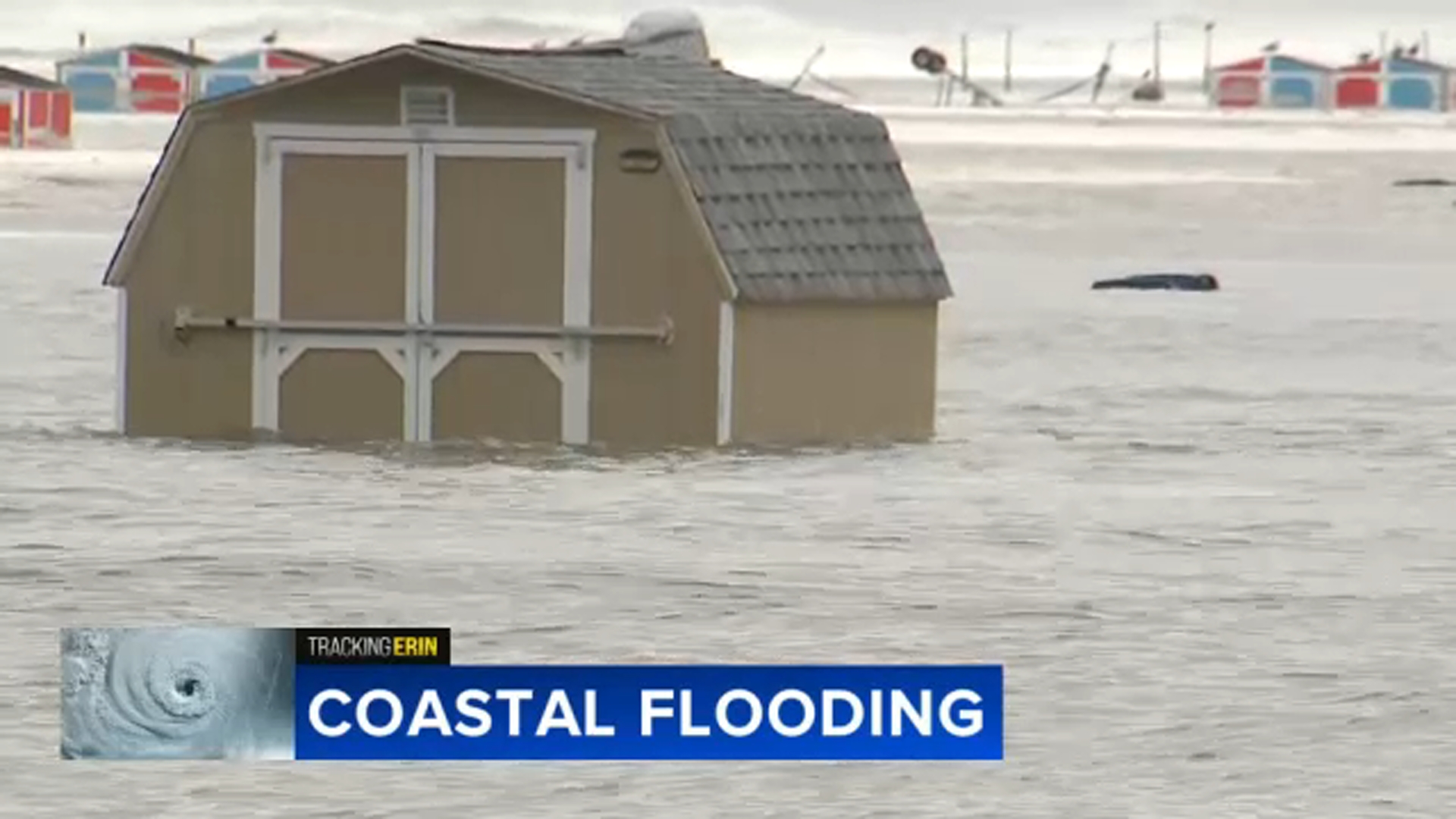
The swollen high tide submerged the beach in Wildwood Crest Thursday night, turning a shed, port-a-potties and trash cans into debris bobbing in the waves.
The seagulls didn't seem to mind.
Flooding in the West Atlantic City section of Egg Harbor Township left vehicles, homes and businesses -- including a gas station -- partially submerged.
Motel parking lots turned into lakes.
The Black Horse Pike flooded out, which is not uncommon when we get a storm of this size offshore.
Police were utilizing a high-water Humvee to get around.
Ocean City offered a similar scene.
An Action News crew rolled through, where nearly a foot of flooding piled up on the streets.
However, don't put your guard down, because rough surf and flooding is still a concern Friday and Saturday, with high tide at 8 a.m.
As Hurricane Erin moves out deeper into the Atlantic Ocean, away from the East Coast, the impacts of the storm were even felt in Philadelphia, without a drop of rain falling from the sky.
The force of all that extra water from the ocean backed into the Delaware Bay, adding to the high tide along the Delaware River Thursday night.
The river spilled over its banks along Columbus Boulevard at Penn's Landing, near Race Street.
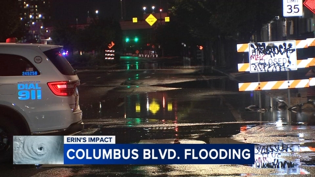
The river rose to moderate flood stage in the city and in Burlington, New Jersey.
Forecasters predict it will hit the same level at 2 a.m. Saturday.
The storm kicked up big waves along the mid-Atlantic coast and began a slow march out to sea after pelting North Carolina's Outer Banks with strong winds and swells that flooded a few places on the barrier islands.
The storm will continue to bring the threat of dangerous rip currents and coastal flooding into the weekend, even as forecasters predict it will gradually weaken.

Erin's strength has fluctuated significantly over the past week. The storm lost some strength on Tuesday and dropped to a Category 2 hurricane as it moved northward, roughly parallel to the East Coast. However, its maximum sustained winds were around 100 mph (160 kph) on Thursday.
Although the weather center was confident Erin would not make direct landfall in the United States, authorities warned that water conditions along the East Coast remain dangerous.
Already this year, there have been at least 27 people killed by rip currents in U.S. waters, according to the National Weather Service. About 100 people drown from rip currents along U.S. beaches each year, according to the United States Lifesaving Association. And more than 80% of beach rescues annually involve rip currents.
RELATED: Jersey shore feeling impacts from Hurricane Erin as it races up the Atlantic Ocean
Although Erin is the first Atlantic hurricane of the year, there have been four tropical storms this hurricane season already. Tropical Storm Chantal made the first U.S. landfall of the season in early July, and its remnants caused flooding in North Carolina that killed an 83-year-old woman when her car was swept off a rural road.
And, at least 132 people were killed in floodwaters that overwhelmed the Texas Hill Country on the Fourth of July.
Just over a week later, flash floods inundated New York City and parts of New Jersey, claiming two lives.
The Associated Press contributed to this report.