Hurricane Otis' Category 5 'nightmare scenario' knocks out all communications in Acapulco, Mexico
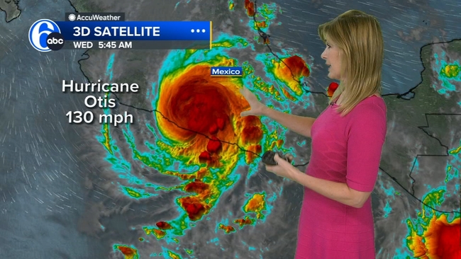
Otis' center slammed into Mexico's coast near Acapulco at around 12:25 a.m. local time with sustained winds of 165 mph.


Hurricane Otis knocked out all communications and unleashed a "nightmare scenario" in Acapulco in southern Mexico on Wednesday morning. Tracking over the incredibly warm ocean water near the coast, the storm rapidly intensified just before landfall and gave officials and residents little time to prepare.
Otis strengthened from a tropical storm to an extremely dangerous Category 5 hurricane in just 12 hours before it slammed ashore as the strongest storm on record to hit this area and the Pacific coast of Mexico.
The sudden burst of power took many by surprise as Otis bore down on Acapulco, a popular tourist destination that's also home to roughly 800,000 people.

As Otis kept strengthening and neared the coast, forecasters at the National Hurricane Center warned that a "nightmare scenario" was unfolding.
Otis' center slammed into Mexico's coast near Acapulco at around 12:25 a.m. local time with sustained winds of 165 mph, the National Hurricane Center said. The much weaker storm is now headed inland and is expected to dissipate over southern Mexico by Wednesday night, the center said.
The storm's full scope of devastation is not yet clear.
Mexico's President Andrés Manuel López Obrador said Wednesday morning his government had no reports of casualties, but all communication systems in the area are down, including with emergency crews on the ground. López Obrador said they had reports of material damage and roads blocked by landslides.
Mexican officials are driving to Acapulco to assess the damage in person given the loss of communications and because officials said the area can't be reached by air.
SEE ALSO: Otis weakens after making landfall in Mexico as Category 5 storm
"We don't have a damage assessment because until now, there is no communication with Acapulco," National Coordinator of Civil Protection Laura Velázquez said in an interview with local news Milenio TV.
"We are going there because we do not have any communication with our colleagues who have already been there for a week doing preventive work for a tropical storm and which in 12 hours became a hurricane," Velázquez explained.
The storm knocked out power to more than 500,000 customers in Mexico's Guerrero state, the power company CFE said in a statement. Power was restored to 40% of those customers, the utility added.
On Tuesday night, the president implored coastal residents of the state of Guerrero, which includes Acapulco, to seek shelter and stay away from rivers, streams and ravines ahead of the storm's landfall.
Guerrero Gov. Evelyn Salgado Pineda announced Wednesday morning temporary shelters were open in Tecpan de Galeana, Coyuca de Benítez and Acapulco.
How the "nightmare" unfolded
Otis was not forecast to become a hurricane until early Tuesday morning, a little more than 24 hours before it would make its unprecedented Category 5 landfall.
A hurricane watch was issued Monday afternoon for Acapulco and surrounding parts of the coast. The forecast was on the "high side of pretty much all the intensity guidance" that forecasters get from computer models, Michael Brennan, director of the National Hurricane Center, told CNN.
But the storm was still severely underestimated. Brennan said the satellite data and hurricane models were underplaying its current intensity and how strong it could potentially get.

Disruptive high-level winds were expected to keep a lid on Otis' strength. But it was a small storm, which made it much more prone to big changes in intensity. As Tuesday progressed, and the storm began to move over incredibly warm water near the coast, it became clear environmental conditions weren't playing out as forecasters expected and Otis was not going to be held back.
The forecasters at the National Hurricane Center were using satellites to estimate the intensity of Otis, a common practice for tropical systems - but there can be problems with this method.
"We don't always have the best, complete picture of what's going on underneath the cloud canopy you see on satellite imagery," Michael Brennan, director of the National Hurricane Center, told CNN.
That's where NOAA's aircraft reconnaissance team, the Hurricane Hunters, come in. Planes drop sensors into the storm to take real-time measurements as they fall through the cyclone, including wind speed and pressure.
"By the time we had the Hurricane Hunter aircraft fly into the storm (Tuesday) afternoon, the data revealed that the storm was about 20 to 30 mph stronger than we would have estimated from just looking at satellite imagery," Brennan told CNN.
Brennan said the NHC typically deploys aircraft reconnaissance in the Eastern Pacific for "hurricane threats to land areas." CNN has asked Brennen why the Hurricane Hunters were not sent into the storm earlier than Tuesday afternoon.
The newly acquired aircraft data confirmed Otis had begun to rapidly intensify and the storm's forecast changed dramatically.
"It's always the worst- case scenario when you have a storm (rapidly intensifying) very close to landfall, when you're having to make significant upward adjustments to the forecast and the reality of the scenario that people are going to face is very different from what they may initially plan for," Brennan told CNN.
Here's how quickly the storm escalated on Tuesday. All times are in Acapulco time.
3 a.m. - 65 mph tropical storm:
The NHC first forecasts a hurricane and says there is "about 1 in 4 chance of rapid strengthening during the next 24 hours."
9 a.m. - 70 mph tropical storm:
The NHC ups its intensity forecast slightly and notes some forecast models show "a greater than normal probability" of rapid intensification and "further upward adjustments to the intensity forecast are possible later today."
Noon - 80 mph Category 1 hurricane
:
The hurricane tracks into very warm water off the Mexico coast and begins rapidly intensifying, aided by moist air and favorable high level winds, two ingredients that allow cyclones to grow stronger. "Further strengthening (is) likely until landfall," the hurricane center warns.
1 to 2 p.m. -
Hurricane Hunters fly through the eye of Otis, discovering it was much stronger than satellites had estimated.
3 p.m. - 125 mph Category 3 hurricane:
The NHC dramatically alters its intensity forecast and calls for an "extremely dangerous" Category 4 hurricane with sustained winds of 140 mph shortly before landfall.
6 p.m. - 145 mph Category 4 hurricane:
T
he NHC warns "...there are no signs of this explosive intensification stopping," and forecasts Otis to reach Category 5 for the first time.
9 p.m. - 160 mph Category 5 hurricane:
The hurricane center warns "a nightmare scenario is unfolding for southern Mexico this evening with rapidly intensifying Otis approaching the coastline."
12:25 a.m. Wednesday -
Otis makes landfall as a 165 mph, Category 5 hurricane.
A symptom of the climate crisis
Otis' intensification was among the fastest forecasters have seen; its top-end windspeed increased by 115 mph in 24 hours and 90 mph in a 12-hour period.
The storm's rapid intensification is a symptom of the human-caused climate crisis, scientists say - and one that is becoming more frequent.
Scientists have defined rapid intensification as a wind speed increase of at least 35 mph in 24 hours or less, generally requiring significant ocean heat.
More than 90% of warming around the globe over the past 50 years has taken place in the oceans, according to the National Oceanic and Atmospheric Administration. In addition, El Niño is growing in the Pacific this year, driving ocean temperatures even higher.
Otis' strengthening "was extremely unusual," Brian McNoldy, an atmospheric scientist at the University of Miami, told CNN. "It's unfortunate it happened right before making landfall, but if this had occurred over the open ocean, it still would have been very remarkable."
Before Otis, there had not been a Category 5 landfall for the East Pacific, according to the NOAA Hurricane Database. The previous strongest landfall was Hurricane Patricia in 2015, which made landfall as a Category 4 Hurricane with winds of 150 mph.
The-CNN-Wire & 2023 Cable News Network, Inc., a Warner Bros. Discovery Company. All rights reserved.