Videos capture Ida's devastation in the Philadelphia region | Live updates
A total of 16 Tornado Warnings were issued on Wednesday due to the storm.

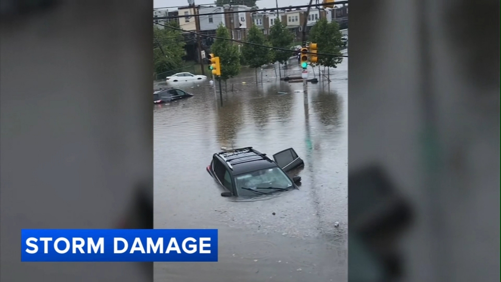
PHILADELPHIA (WPVI) -- The remnants of Hurricane Ida brought heavy winds, drenching rains and at least one tornado Wednesday as the storm battered Pennsylvania and New Jersey.
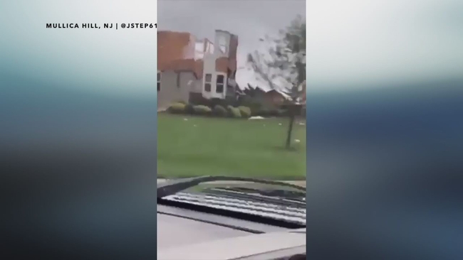
The National Weather Service confirmed at least one tornado and social media posts showed homes reduced to rubble in Mullica Hill, a southern New Jersey county just outside Philadelphia. Crews will survey multiple locations Thursday to determine if a tornado touched down.
A total of 16 Tornado Warnings were issued Wednesday.
- You can share your weather videos and photos with us HERE.
- Stay up-to-date with the latest AccuWeather forecast HERE.
- The latest school closings can be found HERE.
Here are some of the latest updates:
9:01 a.m.: SEPTA Delays
6:57 a.m.: NWS to Survey Area
The National Weather Service will be looking at these seven counties as officials investigate possible tornadoes: Bucks, Chester and Montgomery in Pennsylvania; and Burlington, Gloucester, Salem and Mercer in New Jersey.
5:25 a.m.: Schuylkill River Flooding Manayunk
5:11 a.m.: Amtrak Cancellations
Due to severe weather with significant rainfall along the Northeast Corridor, all service between Philadelphia (PHL) and Boston (BOS) with an initial departure before 9 am on Thursday, Sept. 2 is cancelled. For reservation assistance, please call 800-USA-RAIL.
4:06 a.m.: Rainfall Totals
Coatesville - 9.53"
Spring City - 8.66"
Chester Springs - 8.20"
Malvern - 8.14"
Eagleville - 7.70"
3:55 a.m.: Damage in Ambler, Pa.
1:51 a.m.: Rainfall estimates
1:46 a.m.: All residents and businesses downstream of Pickering Creek Dam are being advised to evacuate the area immediately.
1:30 a.m.: Officials issue evacuation order for parts of Trenton, NJ following severe flooding
Officials have started an evacuation effort in parts of Trenton, New Jersey following severe flooding from the remnants of Ida. Police officers were going door to door along Mount Vernon and Clearfield avenues in The Island neighborhood on Wednesday night.
Read more here.
1:14 a.m. Schuylkill River expected to rise to Major Flood Stage
The Schuylkill River is forecast to rise through this morning to Major Flood Stage. There are multiple rescues from cars stuck in floodwaters. If you live in a flood-prone area, the city is advising shelter-in-place, if safe to do so, until floodwaters recede and it's safe to leave your residence. Call 911 with emergencies.
11:55 p.m. Gloucester County is currently assessing all damage caused by the tornado
10:50 p.m.: Woman killed in Upper Dublin Twp., Pa. due to storm
At least one person has died in southeastern Pennsylvania after severe storms from Ida hit the region on Wednesday. Action News has confirmed that a woman was killed in Upper Dublin Township after a tree came down onto a home. The woman has not been identified. Read more here.
10:42 p.m: Part of PA Turnpike closed
Both directions on the PA Turnpike between the Valley Forge exit and Downingtown exit will be closed for an extended period of time due to significant flooding.
10:36 p.m.: Record flooding expected
Major flooding is now expected for many of our rivers, including the Schuylkill. The forecast crest for Philadelphia Thursday is the second highest on record (since 1869.) This could the worst flooding in more than 150 years.
10:34 p.m. Major flooding to continue
10:22 p.m.: Gov. Murphy declares State of Emergency after Ida wreaks havoc across NJ
"Today, Governor Phil Murphy declared that New Jersey will enter a State of Emergency effective immediately in response to Tropical Storm Ida. Executive Order No. 259 declares a State of Emergency across all 21 counties in New Jersey, allowing resources to be deployed throughout the state during the duration of the storm.
Tropical Storm Ida is severely impacting all areas of our state," said Governor Murphy. "The safety of our residents is our main priority, and we urge everyone to be informed of local weather conditions and to stay off the roads."
10 p.m.: Red Cross supporting three evacuation centers
The American Red Cross Southeastern Pennsylvania Region is currently supporting three evacuation centers for those affected by flooding. Two are being managed by Philadelphia OEM at West Philadelphia High School and Roxborough High School. The third is at Norristown High School in Montgomery County.
Other evacuation centers are open and being managed by county and local officials. Residents should check with their county or municipality for that information.
9:50 p.m.: Video captures storm damage at Fort Washington car dealership

9:30 p.m. Josephine Lane in Mullica Hill, NJ captured tornado on video
9:19 p.m. Lower Gwynedd Twp Chief issues warning to residents
Police are asking Lower Gwynedd Township residents to shelter in place due to flooding in the area. Crews are responding to numerous car rescues and power lines are out all over Fort Washington, said police.
8:53 p.m. Flooding in Chester County on Strasburg Road in West Bradford
8:43 p.m. The Palomino Farms Retention Basin Dam ("Barclay Dam") has crested.
8:40 p.m. Video captures multiple damaged homes in Mullica Hill, NJ after tornado spotted in area
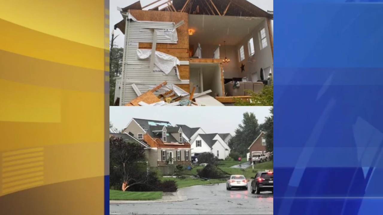
8:30 p.m.: Mike Schubert captured images of a home destroyed in Oxford, Pa.
8:15 p.m.: Downed tree knocks out power in Allentown
8:09 p.m.: devastating storm damage reported in Gloucester County
From Gloucester County Emergency Management: Gloucester County has experienced devastating storm damage. It is likely that multiple tornadoes have touched down within our communities. Our Emergency Operations Center is fully activated with multiple local, county, state, and regional partners assessing damages and deploying resources. If you have an emergency, please dial 9-1-1. Emergency calls are being prioritized based upon severity, so please be patient with our Emergency Personnel and utility companies. We are aware of countless local and state roadways that are impassible and are working at traffic control plans and mitigation efforts. Please limit your travel to emergency needs only.
8:02 p.m. Damage reported in Mullica Hill, NJ
7:57 p.m.: Storm damage in Horsham, Montgomery County on Williamson and Herman Road
7:56 p.m.: Flooding in Lower Merion
7:32 p.m.: Chris Hayes captured this video of a tornado in Burlington County, NJ
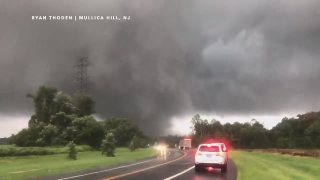
7:30 p.m.: 'Look at that tornado': Ryan Thoden captures twister in Mullica Hill
7:27p.m.: Scott Smith captured video of unconfirmed tornado near Burlington-Bristol Bridge

7:19 p.m.: Damage at Upper Dublin High School
7:12 p.m.: TORNADO EMERGENCY including Trenton NJ, Levittown PA, Hamilton Square NJ until 7:30 p.m.
6:50 p.m.: Storm damage in Willow Grove, Pa.
6:43 p.m.: Tornado Warning for Burlington and Camden County in NJ until 7:15pm
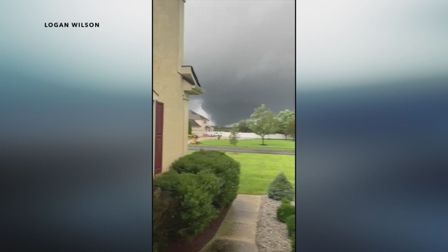
6:40 p.m. Logan Wilson spotted a tornado from his home in Sewell, NJ.
6:32 p.m. Large, 'extremely dangerous' #tornado spotted near Woodbury Heights, NJ
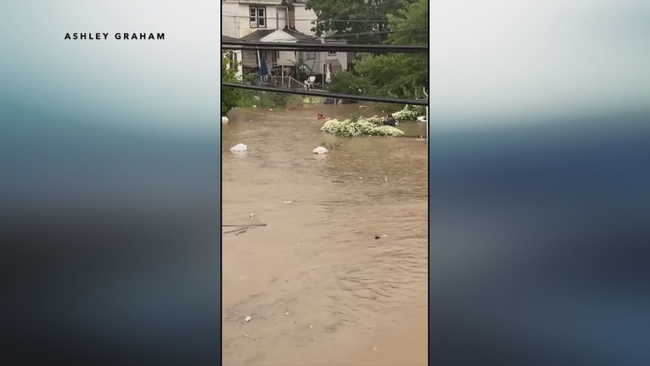
6:31 p.m.: Ashley Graham captured major flooding on 5th Avenue in Coatesville.
6:08 p.m. Heavy rains coming down in Darby Borough on Springfield Road.
6:05: Flooding in Lansdale
5:55 p.m. Confirmed tornado nears Bucks County
5:45 p.m. Flooding on Rt. 30 Bypass

5:42 p.m. Rain in Darby.
5:18 p.m. Flooding in Phoenixville
5:07 p.m. Flooding in Pottstown
TONIGHT: Severe weather including tornadoes is a good possibility for areas near I-95 and south into NJ and Delaware. Flash flooding is most likely north and west of the city.
Rainfall totals: 4 to 6 inches across our far western counties, 2 to 4 inches up and down the I-95 corridor and 1 to 2 for most of south Jersey and Delaware. High 76.
FLASH FLOOD WATCH: It's in effect today and continues through Thursday morning across every local county.
THURSDAY: Rain ends very early although flooding near some waterways may still be an issue through the day. Look for partly sunny skies with lower humidity. It's breezy and cooler with a high of 77.
A Tornado Warning is issued when either a tornado has been spotted or a radar has picked one up. If you are in an area with a tornado warning, it's time to act immediately. Get to a safe space such as a storm shelter. If you don't have one, the best option is usually in the basement or the middle of a building, away from windows, preferably in an area with reinforced walls.
A Tornado Watch is issued when conditions are favorable for a tornado. It doesn't mean severe weather is imminent.